Retiring teacher, coach urges Colony grads to ‘find their 68’
By Jeremiah Bartz Frontiersman.com A football coach using a hockey reference as the centerpiece for his keynote address may


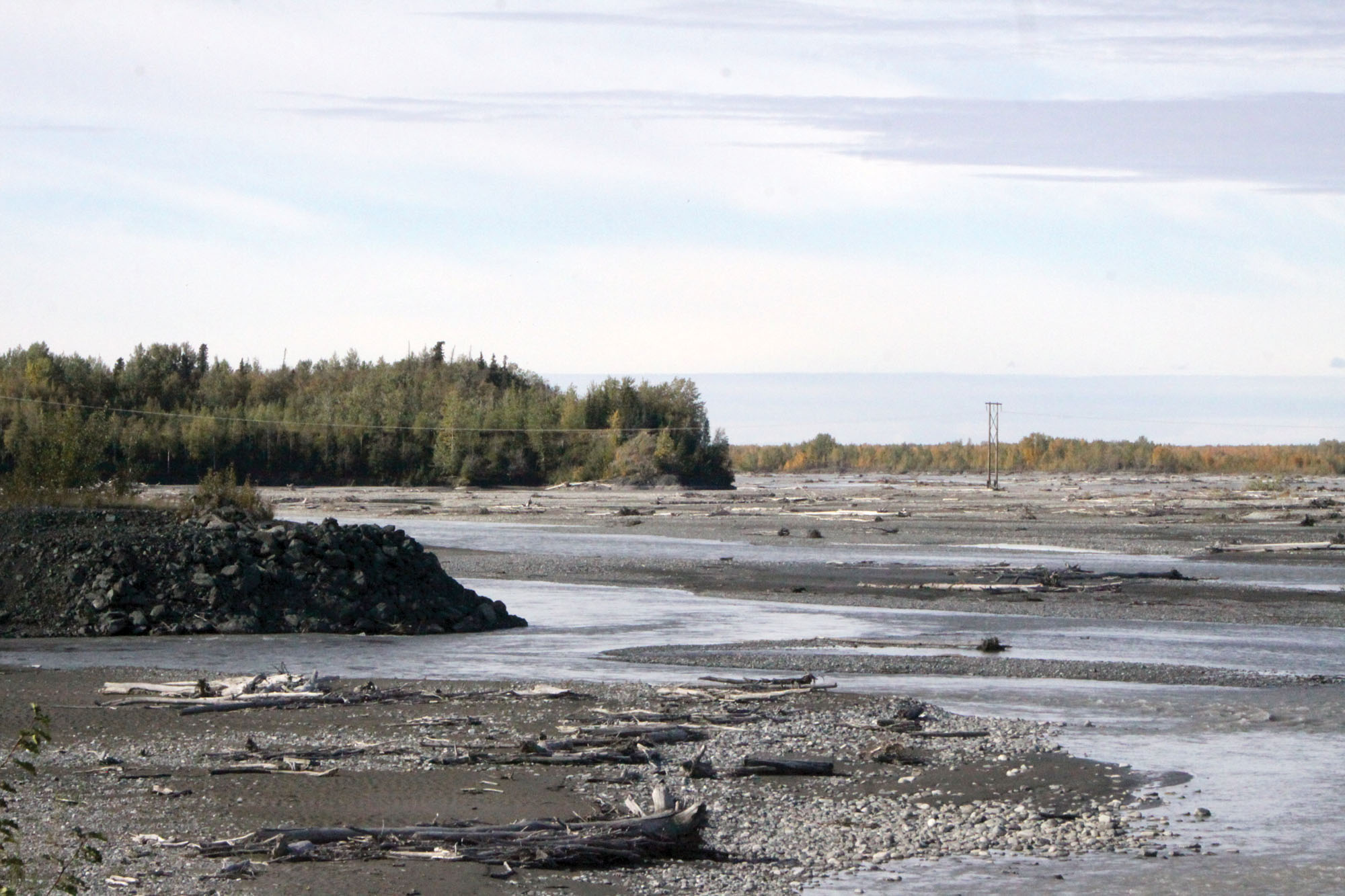
BUTTE — In the undergrowth along East Brian Road, you can still find evidence of the old neighborhood, if you know where to look.
Part of the foundation of what used to be a house pokes out of a riverbank. A rusted metal pipe sticks up out of the gravel bar. It used to connect a now buried and emptied septic tank to the two-story Moline family residence.
Kerry Petersen moved to the Circle View subdivision in the early 1980s, a decade before the Matanuska River slowly started to overtake the neighborhood here. He led a walking tour of the old neighborhood Thursday afternoon.
Starting in 1990, buildings began to disappear. The first house to go was a mobile home, then a greenhouse. Then the Moline house, two barns, farmland, all disappeared in 1991. Some went out on the back of trucks. Others simply were swept in pieces down the Mat River.
That year, the Circle View residents decided they’d had enough. They lobbied borough and state officials to address the problem. State officials, primarily then-Gov. Wally Hickel wanted to provide money to address the flooding and deal with the situation, but there wasn’t a government entity in place to receive funds. So the residents created the Circle View Erosion Control District. In exchange for higher tax rates, residents would pay for the construction and maintenance of four finger dikes.
“That was something new,” Kerry Petersen said. “Nobody’s every done that before. The government cannot give money to private citizens.”
In addition, government money would pay to remove citizens from areas where the tax base wasn’t profitable enough to justify protecting the property, Petersen said. Other properties would be taken off the market as their former owners abandoned them, and the properties were foreclosed, according to Petersen.
In 1994, two houses and a triplex disappeared. Of the three, only one went down the river. The rest moved to other parts of Butte. One wound up in the Springer Loop system. Inhabitants of seven residents of the neighborhood would leave the area in the next decade, but no more houses would wash away.
Near the places where these houses once stood, development is potentially returning again. That makes Petersen and his daughter-in-law Mahana Petersen, nervous. Patti Huntsman, who presently owns Tract B, Circle View Addition No. 4, Tract 2 of Circle View and Tract A-1 Circle view into eight lots to be known as Circle View Ranch. In the same plat, Huntsman is proposing to vacate a 40-foot public easement and replace it with three non-public 30-foot easements. The platte would create a new subdivision in the space between the bulk of Circle View and the river, creating the potential for more construction in an area where, residents like Kerry Petersen say, the river will eventually triumph.
The decision, which was recommended for approval by borough staff, is a situation where borough officials, like Platting officer Paul Hulbert, say they must strictly apply the letter of the law. Hulbert is tasked with recommending plats that don’t create a legal liability for the borough by their creation. Hulbert, who grew up in Butte, says part of the problem is that the borough lacks a comprehensive plan to address erosion.
“It’s not in the ordinance,” he said. “One of the things that the assembly has failed to do is create a zoning overlay for erosion.”
“There’s nothing that we can point at in the code to deny it,” Hulbert added.
Given the absence of effective zoning to prevent the development, the groundwork for a densely populated urban area subject to repeated flooding and requiring periodic installments of taxpayer money are all present, Hulbert said.
“It’s one of these things where people do not want the government to restrict development in hazardous areas,” he said. “When they do develop and things happen, boards are subject to the political pressures.”
Any buildings would have to go before the planning commission and other buildings long before that worst-case scenario emerges, Hulbert points out.
Residents like Kerry Petersen say the easements are necessary to perform the fall maintenance required to keep the river at bay.
“Everybody is opposed to it because you know, if you don’t know history you’re going to repeat the mistakes over and over,” he said.
Residents say they’ve heard the subdivision is being sought to accommodate Huntsman’s family, to allow her to split her holdings evenly among her children. If that is the case, residents like Mahana Petersen are quick to say they don’t want to stand in the way. They just want assurances, Mahana said.
“We want to be indemnified of any financial burden that might happen in the future,” she said. “I’m kind of at that point. As long as you know the risk.”
In general, though, she opposes building along the Mat.
“Overall, I’d say no, it’s not a smart idea,” she said.
Political opposition to hard and fast zoning laws means the borough can’t or won’t enact regulations necessary to prevent more perpetually flooding neighborhoods.
Residents flocked to the Aug. 21 Platting Commission meeting to protest in a public hearing. As a result of their protest, the public hearing has been continued until Sept. 18 at 8:30 p.m., when residents will return.
Contact Brian O’Connor at 352-2269 or brian.oconnor@frontiersman.com

By Jeremiah Bartz Frontiersman.com A football coach using a hockey reference as the centerpiece for his keynote address may

Frontiersman.com With its headquarters in Wasilla, the Frontiersman has been a primary source of news for the Matanuska-Susitna

By Katie Stavick Frontiersman.com The next generation of leaders took flight this week as the Houston High School Class

By Kyle Wilkinson For the Frontiersman Keynote speaker and Carry the Cure President Bill Pagaran’s words boomed through the