Retiring teacher, coach urges Colony grads to ‘find their 68’
By Jeremiah Bartz Frontiersman.com A football coach using a hockey reference as the centerpiece for his keynote address may


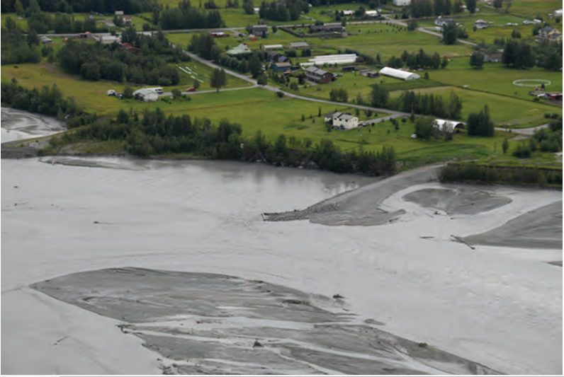
PALMER — Long-awaited relief is on its way. $4.6 million in FEMA relief funds will be awarded to 15 homeowners, should they choose to accept the buyouts, later this month. Ongoing destruction of river banks on properties along mile 13-15 of the Old Glenn HWY in the Butte and five properties along the Matanuska River in Sutton has threatened homes as the river moves from bank to bank. Federal funds will pay for 75% of the costs of fair market appraisal of properties and the state will pay the remaining 25%. Flooding and erosion is nothing new to the banks of the Matanuska, but in the past projects have been designed to help ease the erosion.
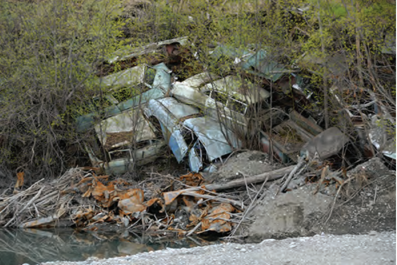
The total cost of the project for the state is just over $1 million. Ed Musial, whose property in Sutton now rests on the bank of the river, used to walk from one bank to the other with his wife when the main channel was on the opposite side. Now the erosion threatens his home.
“All the things you can do to try to defend property against the river, dykes, angled rocks, channelizing, all those things are expensive to do and they all have to be contained. The only thing that doesn’t require maintenance is a buyout. It gets them to a safe place and doesn’t allow structures to be built and they’re removed” said Borough Assemblyman Jim Sykes.
Movement in 2014 towards finding federally available funds frustrated those seeking answers. Funding was awarded to those affected by hurricanes in the south.
“We decided to go after smaller pockets of money and take it one piece at a time. Some of these properties were owned for a long time when the river was never a threat. Water seeks the easiest path. On other side, the river generally does go back and forth, it just takes a long time. If you can’t really see the river you don’t really think it’s a threat, but a lot can happen pretty quickly on these rivers, they're very young geologically.
Sykes referred to a 2011 USGS study in cooperation with the Matanuska Susitna Borough entitled “Geomorphology and Bank Erosion of the Matanuska River, Southcentral Alaska” by Janet Curran and Monica McTeague.
“The braid plain expanded 861 acres between 1949 and 2006. Erosion in the highest category ranged from 225 to 1,043 feet at reaches of bank an average of 0.5 mile long, affecting 8 percent of the banks but accounting for 64 percent of the erosion.”
The study shows aerial photos of bank erosion as early as 1949 and the evolution over time of how the river flows.
“Braiding on the Matanuska River is active, and most non-bedrock banks offer little resistance to erosion. For decades, the river has eroded private properties, a major regional highway, and smaller roads in southcentral Alaska. In the lowlands downstream of Palmer, where farmlands bordered much of the river, this movement of the channel resulted in periodic loss of farmland at least as early as 1956 (U.S. Army Corps of Engineers, 2003). By the 1990s, when individual homes and subdivisions had begun to replace agricultural land uses in this area, the increasing consequence of riverbank erosion led to erosion studies and site-specific erosion control efforts,” said the study.
“It was an incredible good feeling to get the Governor to authorize work outside the road right of way at Mile 15 Old Glenn. We got an early disaster declaration and the equipment to do the job was on site at 7 the following morning,” said Sykes.
Floods took a building into the river in the summer of 2011. Though the measures put in place during the 2016 disaster were swift, they did little to protect other properties along the bank. The FEMA funds will ensure that properties within the disaster area will have their buildings taken down and that there will be no further structures erected along the banks. Sykes chuckles when he mentions that one man has interest in installing a frisbee golf course along the bank.
“I’m ecstatic about it. It’s been slow going. Something is better than nothing and these 15 people have the option to be helped out depending on how they negotiate… The new FEMA flood maps are not allowing subdivisions in flood zones and that’s a good change but it would’ve been nice if these things happened 30 years ago,” said Sykes.

By Jeremiah Bartz Frontiersman.com A football coach using a hockey reference as the centerpiece for his keynote address may

Frontiersman.com With its headquarters in Wasilla, the Frontiersman has been a primary source of news for the Matanuska-Susitna

By Katie Stavick Frontiersman.com The next generation of leaders took flight this week as the Houston High School Class

By Kyle Wilkinson For the Frontiersman Keynote speaker and Carry the Cure President Bill Pagaran’s words boomed through the