Retiring teacher, coach urges Colony grads to ‘find their 68’
By Jeremiah Bartz Frontiersman.com A football coach using a hockey reference as the centerpiece for his keynote address may


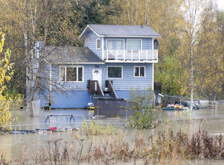
WASILLA — In one corner of the Emergency Operations Center coordinating efforts to respond to floods in the Valley, Jim DePasquale sat in front of a computer.
He wasn’t juggling phones and radios like other people in the room, but his part of the operation is a huge help to the Mat-Su Borough said Clint Vardeman, deputy director of Emergency Services.
“This is technology we didn’t have six years ago,” Vardeman said, referencing the last time the borough saw flooding this severe.
On screen, DePasquale showed a map of Willow Creek, one of the waterways causing all the problems at the moment. The map was three-dimensional, and he could zoom in and out. He said it combined two things — highly accurate aerial photography and LIDAR, a technology similar to sonar that creates a highly detailed topographic map of the borough.
He showed how with a few clicks he could remove trees and just look at the ground, pointed out how incredibly accurate the river mapping was, and showed little red squares and rectangles.
“Those represent the footprints of 50,000 buildings in the borough,” he said.
A few more clicks and the landscape was flooded. The computer was able to predict where water would go when Willow Creek overran its banks. A lot of those red shapes were surrounded by blue water rather than green ground.
“We can look at and evaluate the risk to people’s homes and residences,” DePasquale said. “This is how we plan evacuations.”
He said that matching those footprints to property records, the borough can figure out how many residences are in the area and how many people are likely going to need to be evacuated, and deploy needed resources accordingly.
He said it also came in handy when a swollen Montana Creek started tearing through a dike built along Yoder Road.
DePasquale demonstrated how the program was able to give him a profile of that road and that dike. He then used that information to inform borough officials about how much rock they need to send to repair the damage.
That effort ended up not being enough. Work got to be too dangerous for the borough, which shut it down, DePasquale said. The river wound up going around the dike anyway.
“It’s just fantastic to have this kind of data available to us,” he said. “Otherwise, you’re basically flying blind.”
Contact reporter Andrew Wellner at andrew.wellner@frontiersman.com or 352-2270.

By Jeremiah Bartz Frontiersman.com A football coach using a hockey reference as the centerpiece for his keynote address may

Frontiersman.com With its headquarters in Wasilla, the Frontiersman has been a primary source of news for the Matanuska-Susitna

By Katie Stavick Frontiersman.com The next generation of leaders took flight this week as the Houston High School Class

By Kyle Wilkinson For the Frontiersman Keynote speaker and Carry the Cure President Bill Pagaran’s words boomed through the