Retiring teacher, coach urges Colony grads to ‘find their 68’
By Jeremiah Bartz Frontiersman.com A football coach using a hockey reference as the centerpiece for his keynote address may


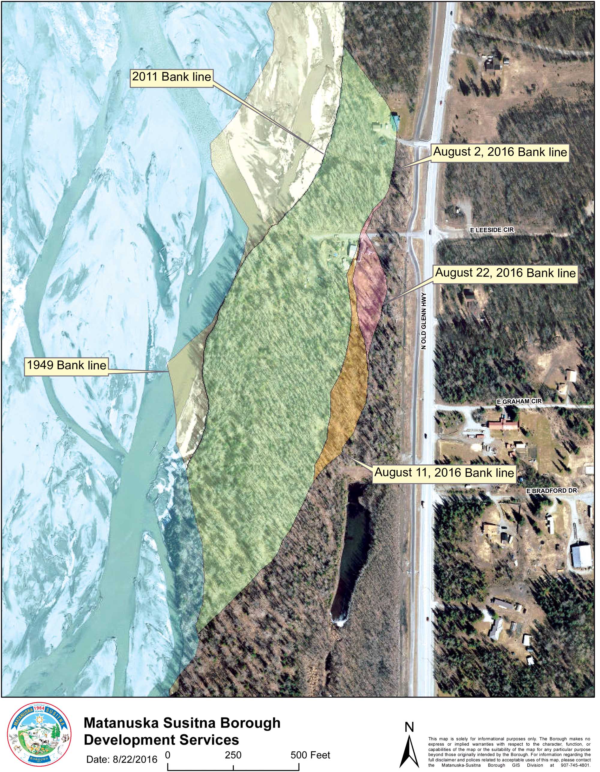
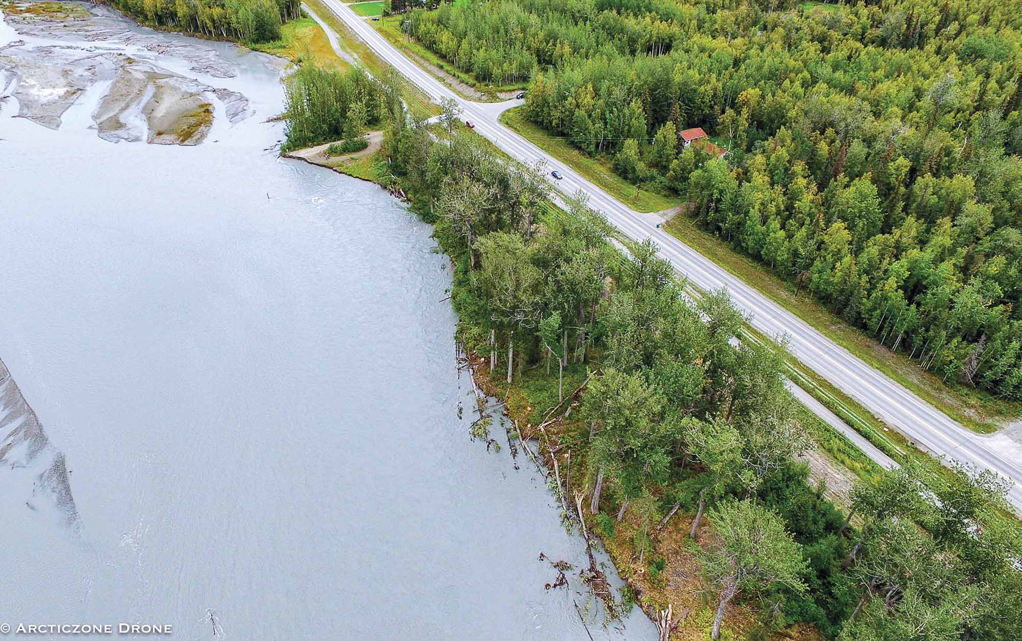
WASILLA — State Department of Transportation managers were moving quickly Tuesday to coordinate containment measures ahead of anticipated flooding caused by erosion along the Matanuska River in Butte.
The move comes a day after Gov. Bill Walker issued a disaster declaration in response to a Matanuska-Susitna Borough request for state assistance in battling what could become a water-inundated zone from Mile 12.5 to 15 along the Old Glenn Highway.
According to the borough, some 25 homes and various outbuildings could be affected if flooding occurs due to the river’s continued erosion, which borough officials said has intensified due to a shift in the river channel. The residents affected are being asked to prepare to evacuate at any time, borough director of emergency services Bill Gamble said Monday.
DOT spokeswoman Shannon McCarthy said survey and maintenance crews were on-site early Tuesday morning, working to locate utilities, such as a nearby six-inch Enstar gas line, stockpiling material and moving riprap into place.
She added an “emergency procurement” procedure was enacted to get a contractor in place quickly for the project. The contractor will likely be on the job Wednesday, McCarthy said.
Borough manager John Moosey granted an easement to the state Tuesday.
Along with the installation of riprap, DOT plans call for the creation of a trench along the west side of the Old Glenn that will be filled with “armour” rock, McCarthy said, which was being staged Tuesday.
“Basically, we are going to dig a trench and fill it with that big armour rock,” McCarthy said, adding that work will be done quickly with the prospect of further erosion looming.
“We want a good 60- to 70-foot buffer between the bank and the trench,” McCarthy said.
On Monday, Matanuska Electric Association crews removed a power pole that had served a home abandoned to the river.
“That pole wasn’t serving anyone,” said MEA spokeswoman Julie Estey. “The crews are monitoring two additional poles nearby. If there is further erosion in that area they will remove those as well.”
An MEA crew installing a new stabilizing guy wire on a pole near the river hit water Monday while digging a hole for an anchor.
Farther downstream, large cottonwood trees that had been felled by local residents in an effort to slow the erosion lay chained or strapped to their stumps. The trees fronted a stretch of shoreline that was being scoured by the main channel of the river, creating an ever-narrower strip of land between the Matanuska and a long pond that sits some five feet lower than the river.
Thomas Swarthout, who lives on the corner of Smith Road and the Old Glenn, said Monday if the river breaks through to the pond, the flooding will be immediate.
“Once it hits the pond, it’s all over,” he said.
The soil being eaten away at a rapid rate is old riverbed sediment made up mostly of sand and gravel, said Janet Curran, a hydrologist with the U.S. Geologic Survey’s Alaska Science Center. Curran is familiar with the Matanuska — she was one of the authors of a 2011 study that looked at erosion on the river’s 74 miles of bank since 1949.
“That is all sand gravel that is easily eroded,” Curran said of the location, “and it is definitely a main channel running there… If you look at the borough LIDAR (survey) mapping, that is an old path of the river.”
Once piece of the 2011 USGS study used historical photos to find channel patterns and the occurrence of vegetation in an effort to measure sustained erosion. The study determined the average age of vegetation on the 2006 braid plain was estimated at 15 years.
“These results indicate that over the past 150 years, surfaces in the braid plain have been stable on average for only a few decades before being reworked by the river,” according to the study. “Although this cannot be used to predict future channel occupation at a particular location, it is a critical measure of general expectations of frequency of channel occupation.”
The study revealed that while some channels remained stable for years, allowing trees to grow, other growth was quickly wiped out when the river returned to a former path.
“It is a big, braided river,” Curran said. “This is a continuation of the those events from 2012 and 2013.”

By Jeremiah Bartz Frontiersman.com A football coach using a hockey reference as the centerpiece for his keynote address may

Frontiersman.com With its headquarters in Wasilla, the Frontiersman has been a primary source of news for the Matanuska-Susitna

By Katie Stavick Frontiersman.com The next generation of leaders took flight this week as the Houston High School Class

By Kyle Wilkinson For the Frontiersman Keynote speaker and Carry the Cure President Bill Pagaran’s words boomed through the