Retiring teacher, coach urges Colony grads to ‘find their 68’
By Jeremiah Bartz Frontiersman.com A football coach using a hockey reference as the centerpiece for his keynote address may


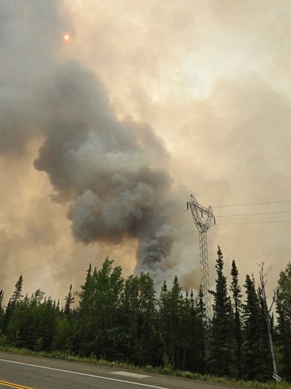
Wildfires near Eureka Roadhouse and Healy have been keeping firefighters busy and residents on edge as the Alaska Division of Forestry & Fire Protection (DOF) is closely monitoring several active wildfires. The DOF teams have been working with local partners to safeguard lives, communities, and infrastructure, while the Parks and Glenn Highways may be impacted by fire activity.
The Nelchina Glacier Fire (#226), located five miles south of Eureka and west of the Nelchina Glacier grew from 750 acres as of June 21, to over 2,200 acres on June 23. It continues to be highly visible along the Glenn Highway near the iconic Eureka Roadhouse as the fire burns in a northerly direction as it feeds off of black spruce and tundra.
Fire crews continue to place pumps and hose lays near structures in close proximity to the Eureka Roadhouse as well as residential homes nearby. The placement of pumps and hoses gives firefighters the opportunity to take an offensive posture to suppressing the fire in the event the fire crosses Eureka Creek and moves northwest towards those structures. Currently, the fire is 3 miles to the southeast of the structures along the Glenn Highway near mile marker 128.
Aviation assets continue to play a vital role in fire suppression on the fire and are helping in slowing the fire’s advance. Over the weekend, the Alaska National Guard provided 2 UH60 Blackhawks to the support firefighting support. These helicopters utilize 700-gallon water buckets to transport water to the fire line to knock the active flames down while cooling hotspots that may be problematic as the fire behavior increases.
Masticators, also known as a forestry mulchers, pieces of heavy equipment used for clearing vegetation, have also been brought in to help create firebreaks and remove vegetation in advance of the fire, clearing approximately 4 miles of brush and small deciduous trees on state lands south of the Glenn Highway between mile markers 129 and 133 to provide a fuel break between the fire and structures in the area.
Officials with the Alaska DOF say smoke will continue to be highly visible as the fire remains active along the northern perimeter. Fire crews and equipment will continue to work along the Glenn Highway between mile markers 120 and 140, and the public is reminded to slow down in those areas to provide safety for firefighters.
At this time there is not a threat to the public and fire managers are proactively placing crews, equipment and aviation resources in locations to stop the advance of the fire.
Access to the fire area remains challenging due to its proximity to glacier-fed rivers, soft tundra, and limited road infrastructure. Firefighters are navigating these challenges and continue to assess opportunities for further action as conditions change.
Another fire to be aware of for those traveling to Denali is the Bear Creek Fire north of Healy. The fire is active and burning just west of the Parks Highway at Mile Post 260 to 270.
The fire experienced drastic wind shifts on June 22nd, redirecting fire activity several times throughout the day. The active fire behavior along the Parks Highway has posed a threat to structures in the area, including power lines and cell towers. The Pioneer Peak Hotshots conducted tactical burning operations for point protection around these values at risk off Bear Creek and Washington Drive throughout the shift on June 24, while aerial resources have been working to slow fire spread around the perimeter of the fire.
Earlier in the weekend, the Denali Borough issued evacuations due to escalating fire conditions, threatening homes and infrastructure. Level 1, 2, and 3 (READY, SET, GO) evacuations in effect.
A cell tower in the fire area has been disabled, limiting communication capabilities for residents, travelers, and fire response personnel, while Denali Borough officials are aware of reports of damaged structures within the fire area. As soon as it is safe to do so, the borough will gather damage information to share with property owners.
Drivers can expect delays along the Parks Highway as it has been subject to periodic temporary closures between mileposts 259-278, due to fire activity on the highway and to provide for firefighter safety as they work to contain spots across the highway. The situation remains dynamic and long closures should be expected. Drivers are advised to check www.511.alaska.gov/map for real-time highway updates.
An Unmanned Aerial System (UAS/drone) is being utilized to assist as it works to detect spot fires and detect other structures at risk around the perimeter of the fire. This information is used to target helicopter bucket drops.
Fire behavior was active yesterday, and due to fire operations along the Parks Highway, the highway was closed for 10 hours with short windows in which it was safe enough to get some vehicles through. The winds shifted out of the northwest sending heavy smoke towards Ferry and Healy, leading to some of the worst air quality levels in the State. To help provide for firefighter safety and support incoming resources on the fire, the Alaska Complex Incident Management team will take over command of the fire today.
Statewide, there have been over 285 wildfires, stretching response resources. With so many fires across the Alaskan landscape, fire managers across the state are prioritizing fires and shifting resources from one location to another across the state to provide the most rapid response to new and existing fires. Fire resources stationed in the Mat-Su, Kenai, and Copper River response areas have been mobilized to the Interior of Alaska to assist with new initial attack fires and rapid rates of spread brought on by unseasonably warm temperatures, receptive fuels and an abundance of lightning associated with our current weather pattern.
For more information regarding Alaska wildland fires, please visit www.akfireinfo.com

By Jeremiah Bartz Frontiersman.com A football coach using a hockey reference as the centerpiece for his keynote address may

Frontiersman.com With its headquarters in Wasilla, the Frontiersman has been a primary source of news for the Matanuska-Susitna

By Katie Stavick Frontiersman.com The next generation of leaders took flight this week as the Houston High School Class

By Kyle Wilkinson For the Frontiersman Keynote speaker and Carry the Cure President Bill Pagaran’s words boomed through the