Retiring teacher, coach urges Colony grads to ‘find their 68’
By Jeremiah Bartz Frontiersman.com A football coach using a hockey reference as the centerpiece for his keynote address may


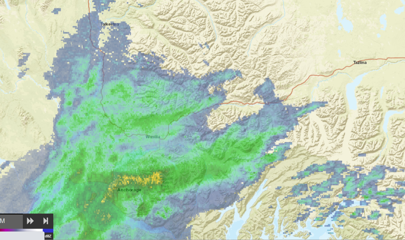
After weeks of near-record high temperatures and dry conditions, the weather pendulum has swung the other way and given Southcentral Alaska the longest stretch of rain precipitation measuring more than .05 inches since 2010.
The forecast for the next several days do not offer any let up at this time. Alaska remains under the influence of a broad and deepening trench of low pressure, meaning conditions will remain breezy with waves of rain similar to the previous week’s pattern of rain.
The National Weather Service has issued a special weather statement as the rain continues to fall across southcentral Alaska. Rain will continue through Tuesday night into Wednesday, with additional rainfall amounts in the Matanuska Valley expected to be from .50 inches to .75 inches.
Widespread rain is also expected Wednesday afternoon through Thursday morning and again late Thursday into Friday. A weather system moving out of Siberia will intensify as it moves across the northern Bering Sea into northern Alaska over the next several days. This will cause a series of low pressure systems to form over the Aleutians before moving across southern Alaska during the week, all but ensuring that measurable rain will occur every day this week.
While all of the rain has been helpful in reducing the fire risk and the moderate drought, the rain needs to go somewhere, and that is to the rivers, streams, and creeks that dot the landscape. The additional rain could push small streams and creeks to bankful or slightly above bankful. Smaller rivers could see water levels rise while larger rivers are expected to remain below bankfull. In urban areas, drivers should be aware of ponding of water and localized flooding on poorly drained roadways, and urged to use caution when driving or when recreating along or on area waterways.
The Mat-Su Department of Emergency Services (DES) has also issued a statement warning residents to monitor water conditions in areas prone to flooding, in flood zones or to other low laying areas near streams or rivers.
“Many area streams and rivers are currently flowing high and fast, approaching action or flood stages. Be sure to know a safe way out of your area if it starts to flood and have the necessary personal supplies and medications needed to spend time away from your home. If you cannot evacuate due to rising water levels call 911.”
Anglers and dipnetters should be advised that while many of the rivers from the Yukon River south may not be in flood stage, waters are high and running fast, so extra safety precautions should be practiced right through the weekend.
DES also advised anyone planning to camp or recreate near local streams or rivers, be aware that water levels can change rapidly, and asks people to avoid camping on sandbars or areas know to be affected during times of high water.
“Be especially aware of high water levels, faster than normal moving water, and floating debris. All these items are be a risk to people boating, rafting, canoeing or spending time in the water. Conditions can change rapidly affecting your ability to traverse or cross waterways, even if you recently made it through safely,” the statement read.
All of this wet weather has now swung the pendulum from being very dry to the 8th wettest start of the year, at 2.23 inches above normal. July is now nearly an inch and a half above normal, at 1.42 inches to be exact, and will likely continue to rise.

By Jeremiah Bartz Frontiersman.com A football coach using a hockey reference as the centerpiece for his keynote address may

Frontiersman.com With its headquarters in Wasilla, the Frontiersman has been a primary source of news for the Matanuska-Susitna

By Katie Stavick Frontiersman.com The next generation of leaders took flight this week as the Houston High School Class

By Kyle Wilkinson For the Frontiersman Keynote speaker and Carry the Cure President Bill Pagaran’s words boomed through the